


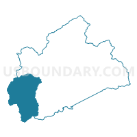
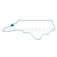
Voting District SPRING, Madison County, North Carolina
About
Outline

Summary
| Unique Area Identifier | 640683 |
| Name | Voting District SPRING |
| County | Madison County |
| State | North Carolina |
| Area (square miles) | 65.36 |
| Land Area (square miles) | 65.36 |
| Water Area (square miles) | 0.00 |
| % of Land Area | 100.00 |
| % of Water Area | 0.00 |
| Latitude of the Internal Point | 35.77539680 |
| Longtitude of the Internal Point | -82.88372780 |
Maps

Graphs
Select a template below for downloading or customizing gragh for Voting District SPRING, Madison County, North Carolina


Neighbors
Neighoring Voting District (by Name) Neighboring Voting District on the Map
- Voting District 63.1, Buncombe County, NC
- Del Rio Voting District, Cocke County, TN
- Voting District FC-1, Haywood County, NC
- Voting District HOT-SP, Madison County, NC
- Voting District SANDY, Madison County, NC
- Voting District SOUTH, Madison County, NC
- Voting District WALNUT, Madison County, NC
Top 10 Neighboring County Subdivision (by Population) Neighboring County Subdivision on the Map
- District 1, Cocke County, TN (4,999)
- Township 5, Walnut, Madison County, NC (1,790)
- Sandy Mush township, Buncombe County, NC (1,407)
- Fines Creek township, Haywood County, NC (1,266)
- Township 6, Hot Springs, Madison County, NC (1,254)
- Township 1, South Marshall, Madison County, NC (1,194)
- Township 8, Spring Creek, Madison County, NC (914)
- Township 9, Sandy Mush, Madison County, NC (551)
Top 10 Neighboring Unified School District (by Population) Neighboring Unified School District on the Map
- Buncombe County Schools, NC (199,157)
- Haywood County Schools, NC (59,036)
- Cocke County School District, TN (28,717)
- Madison County Schools, NC (20,764)
Top 10 Neighboring State Legislative District Lower Chamber (by Population) Neighboring State Legislative District Lower Chamber on the Map
- State House District 114, NC (73,570)
- State House District 118, NC (69,261)
- State House District 11, TN (63,426)
Top 10 Neighboring State Legislative District Upper Chamber (by Population) Neighboring State Legislative District Upper Chamber on the Map
- State Senate District 1, TN (185,350)
- State Senate District 49, NC (172,441)
- State Senate District 47, NC (168,288)
Top 10 Neighboring 111th Congressional District (by Population) Neighboring 111th Congressional District on the Map
Top 10 Neighboring Census Tract (by Population) Neighboring Census Tract on the Map
- Census Tract 105, Madison County, NC (4,816)
- Census Tract 9201.02, Haywood County, NC (3,818)
- Census Tract 26.03, Buncombe County, NC (3,497)
- Census Tract 102, Madison County, NC (2,294)
- Census Tract 104, Madison County, NC (1,911)
- Census Tract 9204, Cocke County, TN (1,678)